Praegu on Läänemeres palju jääd. Veebruari alguses oli juba ligi
veerand merest jääga kaetud
. Eesti rannikul on
jää paksus kohati üle 30 sentimeetri
.
veerand merest jääga kaetud
Tõlge fraasile: veerand merest jääga kaetud
EN
a quarter of the sea covered with ice
jää paksus kohati üle 30 sentimeetri
Tõlge fraasile: jää paksus kohati üle 30 sentimeetri
EN
ice thickness in places over 30 centimeters
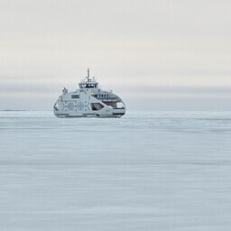
Jää häirib praamiliiklust
saarte ja mandri vahel. Samuti teeb see talvise navigatsiooni keerulisemaks. Satelliitpiltidelt saab näha
jää levikut ja muutusi
.
Jää häirib praamiliiklust
Tõlge fraasile: Jää häirib praamiliiklust
EN
Ice disrupts ferry traffic
jää levikut ja muutusi
Tõlge fraasile: jää levikut ja muutusi
EN
ice spread and changes
Satelliitpildid aitavad
ka
talvise navigatsiooni planeerimisel
. Neid kasutatakse juba 1980. aastatest. Tänapäeval on sensorid ja satelliidid paremad, mis annavad täpsemat infot merekeskkonna kohta.
Satelliitpildid aitavad
Tõlge fraasile: Satelliitpildid aitavad
EN
Satellite images help
talvise navigatsiooni planeerimisel
Tõlge fraasile: talvise navigatsiooni planeerimisel
EN
planning winter navigation
Tänavune talv on võrreldes viimase 10 aastaga rohkem jäärikas. Kui aga vaadata viimase 30 aasta talvesid, on tänavune talv pigem tavaline. Ekstreemsetel talvedel on Läänemerel jäänud veelgi rohkem jääd.
Veebruari alguses võib jääd veelgi juurde tulla. Prognoosid näitavad, et
jää võib katta kuni poole Läänemere pindalast
. See tähendab, et peaaegu kogu Eestit ümbritsev meri võib jäätuda.
jää võib katta kuni poole Läänemere pindalast
Tõlge fraasile: jää võib katta kuni poole Läänemere pindalast
EN
ice may cover up to half of the Baltic Sea's surface
Tulevikus on talved siiski lühemad ja vähem külmad. Kliima soojeneb, aga see ei ole pidev protsess. Ka edaspidi võib olla külmaid talvesid, mis mõjutavad sadamaid, laevaliiklust ja tuuleparke.
Jääolude prognoosid
aitavad planeerida merega seotud tegevusi. Näiteks saab ennustada, kus võib tekkida
rüside hunnikud
, mis takistavad laevaliiklust.
Jääolude prognoosid
Tõlge fraasile: Jääolude prognoosid
EN
Ice condition forecasts
rüside hunnikud
Tõlge fraasile: rüside hunnikud
EN
piles of ridges
Tulevikus on oluline analüüsida ka mineviku kliimaandmeid ja tuleviku projektsioone. See aitab paremini planeerida ranniku- ja avamererajatisi. Tallinna Tehnikaülikool arendab ka
mere digitaalse kaksiku lahendusi
, mis aitavad paremini mõista merekeskkonna protsesse ja teha
täpsemaid prognoose
.
mere digitaalse kaksiku lahendusi
Tõlge fraasile: mere digitaalse kaksiku lahendusi
EN
digital twin solutions for the sea
täpsemaid prognoose
Tõlge fraasile: täpsemaid prognoose
EN
more accurate forecasts
Currently, there is a lot of ice in the Baltic Sea. By early February, nearly a quarter of the sea was already covered with ice. Along the Estonian coast, the ice thickness in some places exceeds 30 centimeters.
The ice disrupts ferry traffic between the islands and the mainland. It also makes winter navigation more difficult. Satellite images allow us to see the spread and changes in the ice.
Satellite images also assist in planning winter navigation. They have been used since the 1980s. Today, sensors and satellites are more advanced, providing more accurate information about the marine environment.
This winter has been more icy compared to the last 10 years. However, when looking at the winters of the last 30 years, this winter is rather typical. In extreme winters, even more ice has covered the Baltic Sea.
In early February, more ice could form. Forecasts indicate that the ice could cover up to half of the Baltic Sea. This means that almost the entire sea surrounding Estonia could freeze.
In the future, winters will be shorter and less cold. The climate is warming, but this is not a continuous process. There may still be cold winters in the future, affecting ports, shipping, and wind farms.
Ice condition forecasts help in planning maritime activities. For example, they can predict where ice piles may form, obstructing shipping.
In the future, it will be important to analyze both past climate data and future projections. This will help in better planning coastal and offshore structures. Tallinn University of Technology is also developing digital twin solutions for the sea, which will help better understand marine processes and make more accurate forecasts.