Analysis of satellite images shows that the Baltic Sea ice period began in the second half of November.
Due to warmer-than-average weather, not much ice formed until the end of December.
At the beginning of January, the cold arrived, and the ice cover began to grow rapidly. The ice expanded until mid-February.
The ice first formed in the northern part of the Gulf of Bothnia and then in the Neva estuary and along the western coast of Estonia.
The maximum extent of the ice was reached on February 20. At that time, the ice covered nearly 155,000 square kilometers, over one-third of the Baltic Sea's surface.
Professor Rivo Uiboupin from Tallinn University of Technology said that this ice period was record-breaking in the last 10 years.
However, the extent of the ice cover was smaller than in 2011, when the ice covered almost 300,000 square kilometers.
The Estonian coast was almost completely frozen. Ice of varying thickness covered Väinameri, Pärnu Bay, and most of the Gulf of Finland.
Open water could only be seen along the northwestern coast of Estonia and near Hiiumaa and Saaremaa.
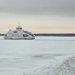
In February, ice roads were open from the mainland to Vormsi and Kihnu, as well as between Hiiumaa and Saaremaa.
January and February were colder than average. The ice period lasted until the beginning of April.
The official ice-breaking period ended on April 13.
Compared to previous winters, this year's ice period was shorter. Ice only formed in January, and most of it disappeared before May.
Professor Uiboupin said that climate change does not make the weather linearly warmer. Cold winters can still occur.
This winter, icebreakers operated for 98 days. In the future, similar winters may still occur.