Satelliitpiltide analüüs
näitab, et Läänemere jääperiood algas novembri teises pooles.
Satelliitpiltide analüüs
Tõlge fraasile: Satelliitpiltide analüüs
EN
Analysis of satellite images
Keskmisest soojemate ilmade tõttu ei tekkinud palju jääd kuni detsembri lõpuni.
Jaanuari alguses tuli külm ja jääkate hakkas kiiresti kasvama. Jää laienes kuni veebruari keskpaigani.
Jää tekkis esmalt Botnia lahe põhjaosas ja seejärel Neeva suudme ja Lääne-Eesti rannikualadel.
Jää ulatus oli kõige suurem
20. veebruaril. Siis jää kattis ligi 155 000 ruutkilomeetrit, üle kolmandiku Läänemere pinnast.
Jää ulatus oli kõige suurem
Tõlge fraasile: Jää ulatus oli kõige suurem
EN
The ice extent was the greatest
Tallinna Tehnikaülikooli professor Rivo Uiboupin ütles, et see jääperiood oli rekordiline viimase 10 aasta jooksul.
Siiski oli jääkatte ulatus väiksem kui 2011. aastal, mil jää kattis pea 300 000 ruutkilomeetrit.
Eesti rannik jäätus peaaegu täielikult.
Erineva paksusega jää
kattis Väinamere, Pärnu lahe ja suurema osa Soome lahest.
Erineva paksusega jää
Tõlge fraasile: Erineva paksusega jää
EN
Ice of varying thickness
Vaba vett võis näha
vaid Loode-Eesti rannikul ja Hiiumaa-Saaremaa lähistel.
Vaba vett võis näha
Tõlge fraasile: Vaba vett võis näha
EN
Open water could be seen
Veebruaris olid avatud jääteed mandrilt Vormsile ja Kihnule ning Hiiumaa ja Saaremaa vahel.
Jaanuar ja veebruar olid keskmisest külmemad. Jääperiood kestis aprilli alguseni.
Ametlik jäämurde periood
lõppes 13. aprillil.
Ametlik jäämurde periood
Tõlge fraasile: Ametlik jäämurde periood
EN
Official ice breaking period
Võrreldes eelmiste talvedega oli tänavune jääperiood lühem. Jää tekkis alles jaanuaris ja enamik jääd kadus enne maid.
Professor Uiboupin ütles, et kliimamuutused ei tee ilmast sirgjooneliselt soojemat. Vahele võib tulla ka külmi talvi.
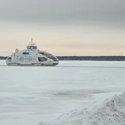
Sel talvel töötasid jäämurdjad 98 päeva. Tulevikus võib väljavoolata veel sarnaseid talvi.
Analysis of satellite images shows that the Baltic Sea ice period began in the second half of November.
Due to warmer-than-average weather, not much ice formed until the end of December.
At the beginning of January, the cold arrived, and the ice cover began to grow rapidly. The ice expanded until mid-February.
The ice first formed in the northern part of the Gulf of Bothnia and then in the Neva estuary and along the western coast of Estonia.
The maximum extent of the ice was reached on February 20. At that time, the ice covered nearly 155,000 square kilometers, over one-third of the Baltic Sea's surface.
Professor Rivo Uiboupin from Tallinn University of Technology said that this ice period was record-breaking in the last 10 years.
However, the extent of the ice cover was smaller than in 2011, when the ice covered almost 300,000 square kilometers.
The Estonian coast was almost completely frozen. Ice of varying thickness covered Väinameri, Pärnu Bay, and most of the Gulf of Finland.
Open water could only be seen along the northwestern coast of Estonia and near Hiiumaa and Saaremaa.
In February, ice roads were open from the mainland to Vormsi and Kihnu, as well as between Hiiumaa and Saaremaa.
January and February were colder than average. The ice period lasted until the beginning of April.
The official ice-breaking period ended on April 13.
Compared to previous winters, this year's ice period was shorter. Ice only formed in January, and most of it disappeared before May.
Professor Uiboupin said that climate change does not make the weather linearly warmer. Cold winters can still occur.
This winter, icebreakers operated for 98 days. In the future, similar winters may still occur.