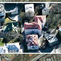
Chancellor of Justice Ülle Madise pointed out that the aerial photos in the geoportal of the Land Board are very detailed. They show irrigation hoses and robotic lawnmowers in people's yards. Aerial photos are photos taken from the air, usually from an airplane or drone.
Several people have contacted the Chancellor of Justice, concerned about their safety. Detailed image material can provide valuable information to malicious individuals.
The Ministry of Economic Affairs is now considering how to limit access to high-resolution images. Possible measures include reducing resolution in public view or releasing data with a time delay.
Ivari Rannama from the Ministry of Economic Affairs said that the most reasonable solution would be to make high-resolution photos available only when a person has authenticated themselves. This would not be overly complicated technically.
Last year, the Land Board published aerial photos with limited resolution. This caused dissatisfaction among some people, as detailed images could not be viewed.
Detailed aerial photos are used by businesses in logistics, real estate development, and agriculture. Easy access to such photos may violate people's privacy, but lack of access could hinder innovation.
Ragnar Viikoja from the Chamber of Agriculture and Commerce said that farmers use high-resolution images, for example, to show field boundaries. The size of the field determines how much support can be received from the European Union.
Surveyor Mart Rae noted that the government is not yet entirely clear on who should have access to high-resolution images. He emphasized that these photos are very important for surveying work and planning.
The Ministry of Economic Affairs and Communications sent a draft amendment to the Spatial Data Act and a service design plan to stakeholders.